
Description
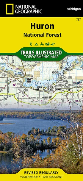
National Geographic Huron National Forest Map – Your Essential Guide to Outdoor Adventures
The National Geographic Huron National Forest Map from The Outdoor Warehouse is meticulously crafted in collaboration with the U.S. Forest Service and Michigan Department of Natural Resources. This essential travel companion is designed for outdoor enthusiasts eager to explore the stunning trails and attractions of northeast lower Michigan.
Constructed with durable, waterproof, and tear-resistant materials, this Trails Illustrated map ensures reliability under outdoor conditions. Coverage includes popular destinations like Au Sable National Scenic River, South Higgins Lake, and various state parks. With clearly marked trails for diverse activities—be it hiking, biking, or snowmobiling—this map caters to all your outdoor needs, showcasing mileage markers along key routes including the Midland to Mackinac Trail.
- Expertly detailed coverage of Huron National Forest and surrounding areas
- Includes recreational features like beaches, boat ramps, and camping spots
- Clearly labeled trails for walking, cycling, ATV, and horseback riding
- Printed on “Backcountry Tough” waterproof, tear-resistant paper
- Full UTM grid included for GPS navigation assistance
Explore the breathtaking landscapes of Huron National Forest with confidence, knowing you have a reliable guide at your fingertips. Available now at The Outdoor Warehouse — your trusted source for outdoor maps and gear.



Reviews
There are no reviews yet.